| Characteristics | Description | |
|---|---|---|
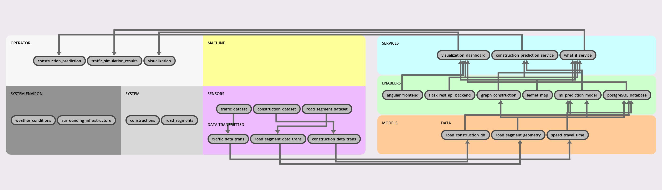
| C1 | System under study | Digital twin system for Montreal road network monitoring and decision support |
| C2 | Physical acting components | constructions: Road areas affected by ongoing construction or maintenance work road_segments: Road sections used for vehicle circulation |
| C3 | Physical sensing components | traffic_dataset construction_dataset road_segment_dataset |
| C4 | Physical-to-virtual interaction | traffic_data_trans road_segment_data_trans construction_data_trans |
| C5 | Virtual-to-physical interaction | The DT provides insights and scenario analysis that support decision-making for road planning and construction management. |
| C6 | DT services | visualization_dashboard: Web-based visualization service providing interactive map and dashboard for monitoring road network state and simulations construction_prediction_service: Predictive analytics service using historical and spatial data to estimate future road construction needs and impacts what_if_service: Interactive simulation service that computes traffic scenarios under different road closure or disruption conditions |
| C7 | Twinning time-scale | The DT is synchronized with updated road construction and traffic datasets. Interactive computation with near-instant response time based on static or preloaded data The DT is synchronized with updated road construction and traffic datasets. |
| C8 | Multiplicities | The current implementation represents a single Digital Twin instance of the Montreal road network, although the framework could be extended to support multiple instances for different cities or scenarios. |
| C9 | Life-cycle stages | The DT supports the design and the service phases. In the service phase, it supports creating, executing, saving, analyzing and terminating. |
| C10 | DT models and data | Model: No data available Data: road_construction_db: Structured dataset containing road construction activities, including work zones, and schedules road_segment_geometry: Geospatial dataset describing road network topology speed_travel_time: Traffic performance dataset containing speed and travel time measurements across road segments over time |
| C11 | Tooling and enablers | angular_frontend: Web frontend framework responsible for rendering the DTInsight dashboard and user interface flask_rest_api_backend: REST API backend providing data access, processing, and orchestration for services graph_construction: Graph-based processing engine used to model and analyze road network relationships for scenario simulation leaflet_map: Interactive map library used to display road network layers, traffic segments, and construction zones ml_prediction_model: Machine learning model used to predict construction needs and traffic impact patterns postgreSQL_database: Relational database storing structured road network data, traffic information, and simulation results |
| C12 | DT constellation | The system integrates multiple software components including an Angular frontend, Leaflet-based map visualization, Flask REST API backend services, PostgreSQL data storage, and machine learning prediction modules. |
| C13 | Twinning process and DT evolution | The Digital Twin was developed incrementally through several stages: collection of open datasets related to road networks, traffic, and construction; integration and structuring of geospatial data into a consistent road network model; development of data storage and processing pipelines; implementation of interactive visualization and what-if simulation services; integration of machine learning models for construction prediction; and continuous refinement of data quality, simulation accuracy, and user interaction capabilities. |
| C14 | Fidelity and validity considerations | The fidelity of the Digital Twin relies on the quality and granularity of publicly available datasets, including road geometry, traffic conditions, and construction information. The road network is represented with accurate geospatial data, while traffic and construction data are periodically updated but may not reflect real-time conditions. Simulation and prediction services provide approximate results based on historical data and learned patterns, and are intended to support decision-making rather than provide exact forecasts. |
| C15 | DT technical connection | The frontend communicates with the backend over HTTP REST APIs, while the backend accesses the PostgreSQL database and prediction services. |
| C16 | DT hosting/deployment | The DT is deployed as a web-based application accessible through a browser. |
| C17 | Insights and decision making | construction_prediction: prediction of future construction needed traffic_simulation_results: what-if simulation of traffic under different road closure scenarios visualization: visualization of road traffic and construction events on the map |
| C18 | Horizontal integration | The Digital Twin integrates multiple software components across the same operational layer, including a web-based frontend, backend services, data storage, and machine learning modules. It also connects to external open datasets related to road networks, traffic conditions, and construction activities, enabling consistent data exchange and coordinated functionality across the system. |
| C19 | Data ownership and privacy | Datasets have been provided online to the public. No privacy-related data are stored. |
| C20 | Standardization | Communication between services is performed through RESTful HTTP APIs and geospatial data. |
| C21 | Security and safety considerations | The Digital Twin ensures security through standard web protocols, including HTTPS for secure communication between frontend and backend services. Access to data and services is controlled via API endpoints, and no sensitive personal data is stored as the system relies on publicly available datasets. From a safety perspective, the DT does not directly control physical infrastructure, and its outputs are intended for decision support rather than real-time automated actions, reducing risks associated with incorrect predictions or simulations. |